The Toll from Coal

Coal-fired power plants are America's greatest air polluters. They are also the most dangerous. The pollution from coal-fired power plants cause global warming, acid rain, and fine particle pollution. There are around 500 coal-fired power plants in the United States. You can view how dangerous each of these coal-fired power plants are on the Toll For Coal interactive map.
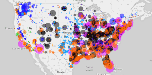
The Toll for Coal interactive map allows you to explore the sulfur dioxide and nitrous oxide emissions expelled by coal-fired power plants across America.If you click on a state on the map you can view a list of all the coal-fired power plants in the state. If you click on an individual power plant you can view details on the size of the plant, the tons of pollutants it emits every year and the health impact of those pollutants.
The health impacts for each power plant include the number of deaths caused, the number of hospital admissions, asthma ER visits and the number of acute bronchitis cases. Around each power plant are circles showing the 3 mile and 12 mile distances from the plant. When you select a plant on the map you can view details about the population demographics who live within these 3 mile and 12 mile areas of the power plant. This includes the number of children living close to the plant.
Coal is still the main source of energy for the USA. You can explore America's power supply on the U.S. Power Plants map. U.S. Power Plants is an interactive map showing the locations, size and type of America's electric power plants. The map is a great way to see where different types of power plant are located, how much each type of energy source contributes to the country's power supply and how much each source contributes to CO2 emissions.
If you click on an electricity power plant marker on the map you can view details on the plant's capacity, net generation and CO2 output. The drop-down menu also allows you to re-scale the map markers by the the amount of CO2 produced by each power plant.


Comments