The Top 5 Historical Photograph Maps
What Was There

What Was There uses Google Maps to show historical photographs in their modern physical context.
Anyone can upload a photograph to What Was There with two straightforward tags to show the pictures location and date. The fun however really comes from browsing the uploaded photographs superimposed on the modern view in Street View.
What Was There includes a slider that allows you to adjust the transparency of the photograph. This really helps in allowing you to compare the photo to the current Street View.
Historypin
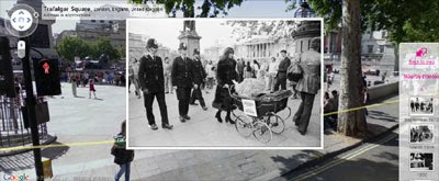
This joint effort from Google and We Are What We Do allows anyone to add historical photographs to Google Maps.
Historypin includes a great interface allowing users to superimpose a photo on the Street View of the location shown in the picture. When users upload photographs to the site they are invited to tell the stories behind the pictures. This makes browsing the uploaded photographs a fascinating experience.
SepiaTown

SepiaTown is a website that geo-tags historical photographs on Google Maps.
You can search the map by location and the thumbnails of available historical photographs will be displayed on the Google Map. You can click on a thumbnail image to see a larger version with file and credit information, as well as notes and commentary.
If you have your own historical photographs you can add them to the map.
LookBackMaps

LookBackMaps is a collection of historical photographs that can be compared to the same current view as seen on Google Maps Street View.
The photographs are geotagged and displayed on a Google Map. Users of the map can select a date range for the photographs that they wish to view. To view a photograph alongside the current Street View just click on any of the pictures inside the information windows.
To add your own historical photographs to the map you just need to register with LookBackMaps.
HistoGrafica

HistoGrafica is an on-line community whose aim is to show in pictures how the world has changed through time. In essence HistoGrafica is an archive of old photographs and pictures tagged on a Google Map.
Bonus Map
There and Then
'There and Then' is my attempt to create a map based portal to view some historical films, uploaded to YouTube, superimposed over their current Street View.
When you select to view a particular Street View you need to use the buttons beneath the map to control the embedded video.
______________
What Was There uses Google Maps to show historical photographs in their modern physical context.
Anyone can upload a photograph to What Was There with two straightforward tags to show the pictures location and date. The fun however really comes from browsing the uploaded photographs superimposed on the modern view in Street View.
What Was There includes a slider that allows you to adjust the transparency of the photograph. This really helps in allowing you to compare the photo to the current Street View.
Historypin
This joint effort from Google and We Are What We Do allows anyone to add historical photographs to Google Maps.
Historypin includes a great interface allowing users to superimpose a photo on the Street View of the location shown in the picture. When users upload photographs to the site they are invited to tell the stories behind the pictures. This makes browsing the uploaded photographs a fascinating experience.
SepiaTown
SepiaTown is a website that geo-tags historical photographs on Google Maps.
You can search the map by location and the thumbnails of available historical photographs will be displayed on the Google Map. You can click on a thumbnail image to see a larger version with file and credit information, as well as notes and commentary.
If you have your own historical photographs you can add them to the map.
LookBackMaps
LookBackMaps is a collection of historical photographs that can be compared to the same current view as seen on Google Maps Street View.
The photographs are geotagged and displayed on a Google Map. Users of the map can select a date range for the photographs that they wish to view. To view a photograph alongside the current Street View just click on any of the pictures inside the information windows.
To add your own historical photographs to the map you just need to register with LookBackMaps.
HistoGrafica
HistoGrafica is an on-line community whose aim is to show in pictures how the world has changed through time. In essence HistoGrafica is an archive of old photographs and pictures tagged on a Google Map.
Bonus Map
There and Then
'There and Then' is my attempt to create a map based portal to view some historical films, uploaded to YouTube, superimposed over their current Street View.
When you select to view a particular Street View you need to use the buttons beneath the map to control the embedded video.
______________


Comments