

You don't see many developers experimenting with the Google Maps API these days. This is a shame, as you can create some amazing visual effects using the satellite imagery from Google Maps - as these experiments will hopefully demonstrate/
Urban Collage allows you to view an animated collage of a number of the same satellite views, seen at different zoom levels. To create your collage you just need to enter two locations (they need to be locations that you can drive between). The application then uses your two locations to slowly pan through the driving route between those two cities. Essentially you are presented with an urban collage of the route as seen at different zoom levels in Google Maps aerial view.
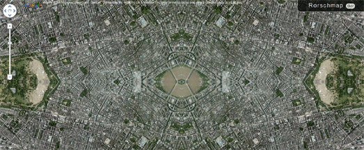
One of the first applications to experiment with cutting up Google Maps satellite views was #rorschmap. #rorschmap uses the Google Maps API to create a kaleidoscope for any location on the Earth.
The application displays the Google Maps satellite view of any location in the world and, using the same principle of multiple reflection that you find in kaleidoscopes, creates an animated Rorschach test effect.

Displayce is another series of visual map experiments created using the Google Maps API. Each of the experimental views in Displayce uses a number of Google Map instances on one page to create an experimental map pattern.
For example, 'foci' (pictured above) overlays a number of Google Maps aerial views on top of each other. Each map instance shows a view of the same location but each map has a consecutively lower zoom level.
Displayce includes four different map experiments all creating a different visual effect by stitching together different map instances to create different patterns. You can enter any location in the world into each of the experiments and, if you like the resulting experimental map, you can grab the URL for the view and share it with your friends.

Of course Google Maps aerial views are often works of art in their own right. The Earth is a beautiful place and that beauty can be found in many Google Maps satellite images.
Chuchichechocha is a Google Maps satellite view slideshow, developed by David Schmidt, which showcases some of the most beautiful views found on Google Maps. The slideshow automatically animates through a large number of beautiful images found in Google Maps.
The application includes controls to pause or to manually navigate through the images. Each image also comes with a unique URL so you can share your favorite views with your friends.
No comments:
Post a Comment