The (Most Depressing) Maps of the Week

Are you prepared for a global pandemic? If an unknown breed of smallpox suddenly emerged in your neighborhood, how long would you survive?
You can find out with Ubisoft's new online pandemic simulation map. Collapse presents a simulated pandemic outbreak centered around your home and neighborhood. At the beginning of the simulation you are infected with an unknown breed of smallpox. As the simulation plays out the map shows how the infection could spread through your immediate neighborhood, the rest of the country and eventually the rest of the world.
The map makes extensive use of the Google Places API to show how real-word actions could quickly lead to a widespread pandemic. Unfortunately all those local businesses that feature in your personalized neighborhood map are unlikely to survive once all your neighbors have died.

If the thought of a global smallpox pandemic hasn't depressed you enough then you can depress yourself further with this interactive map of global security risks. The RiskMap is a new, free to use security and risk mapping portal. The map allows you to access news and real-time intelligence about the current risk situation in countries around the world.
Countries on RiskMap are colored based on the current global risk level; the colors displayed range from green (safe) to red (critically unsafe). The map also displays hundreds of the latest events and incidents related to security events across the globe.
RiskMap looks at events and incidents of interest from over 1,000 different sources, It calculates the risk represented by each of these incidents and attempts to identify the type of risk posed and the facts of the incident such as the number of fatalities or casualties, It then selects the most important information from the original source and creates a summarized copy of the event for the map.
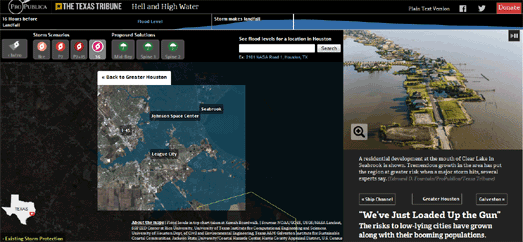
Now to depress you even further we take you to Hell and High Water.
On September 11th 2008 the National Weather Service issued a severe warning to Houston residents,
ALL NEIGHBORHOODS, AND POSSIBLY ENTIRE COASTAL COMMUNITIES, WILL BE INUNDATED. PERSONS NOT HEEDING EVACUATION ORDERS IN SINGLE FAMILY ONE OR TWO STORY HOMES WILL FACE CERTAIN DEATH.The warning was issued because of the imminent threat of Hurricane Ike, which at the time was heading directly towards central Houston. Luckily, on September 13th, Hurricane Ike shifted course and eventually hit land a little north of the city. The storm still caused $30 billion in damage and killed at least 74 people in Texas.
The Texas Tribune and ProPublica argue that it is only a matter of time before a perfect storm will hit Houston, potentially killing thousands of residents.
Hell and High Water is a mapped visualization of the dangers Houston faces from a future hurricane. The mapped interactive simulates the likely effects of a number of potential storms on the city of Houston. Each of these simulations overlays the track of a potential storm over a satellite view of the city. These tracks are then animated to show the likely flooding events that could take place in Houston if such a storm hit the city.


Comments