Mapping the History of Undersea Cables

Messages in the Deep is a fascinating Google Map which allows you to explore the history of the growth of the undersea fibre optic network around the world since 1989.
The map allows you to view the undersea cable network for any year, or you can animate the map to view how this global network has grown since 1989. The map also allows you to refine the cables shown by cable owner.
You can click on any of the cables displayed on the map to view it's length, it's first year of operation and the cable's owners.
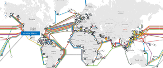
TeleGeography's Google Maps API version of the Submarine Cable Map, looks at the physical connections that make it possible for the internet's data to travel around the world. This map is an interactive version of TeleGeography's annual Submarine Cable wall map, which you can purchase directly from the website.
The Google Map version allows users to click on the landing point hubs to reveal a list of all submarine cables landing at a station. The Google Map makes great use of Google Map styles and custom info windows to create a map that is both functional and great to look at.

Greg's Cable Map is another Google Map of the world's undersea communications infrastructure. The map displays the major cables that allow internet and other data to travel from the other side of the world, across the oceans and into your home.
It is possible to click on any of the displayed cables (or select it from the side menu) and view details about the cable's schematic accuracy and the locations that it connects.


Comments