Get Me Geodata!
Hans Hack is on a bit of a creative blitz. In the last couple of weeks he has released the impressive How Big size comparison map tool and the equally impressive shape comparison tool, Reprojector. Both of these tools can be used to get the GeoJSON data needed to compare different locations or sized objects on top of an interactive map.
Now Hans has released yet another interactive mapping tool. This new tool can be used to retrieve geographical data from OpenStreetMap. OpenStreetMap is the world's biggest source of geographical data which is available to use under an Open Database Licence. If you work with interactive maps in any way then you will want to be able to access OpenStreetMap data. My favorite tool for accessing OSM data is Overpass Turbo, which is a relatively easy to use web based interface for using the Overpass API.
Overpass Turbo uses the Overpass Query Language so it isn't completely straightforward to use without help (although the built-in wizard is very useful and there is a lot of support and examples on the internet for how to write Overpass Turbo queries).
Hans Hack's new tool Gimme Geodata seems to be designed as an entry level tool for grabbing data from OpenStreetMap. The tool is a fantastic resource if you want to quickly grab the boundary of any country or administrative level in the world in GeoJSON format. Click on the Gimme Geodata interactive map and it will provide a list of all the available boundaries which you can download.
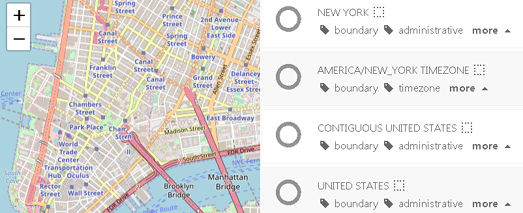
For example if you click on Chinatown in New York City you are presented with the option to download any or all of the following boundaries:
- Chinatown
- Manhattan Community Board
- Manhattan Island
- Manhattan
- New York City
- New York County
- New York State
- New York Timezone
- Contiguous United States
- United States
Gimme Geodata is probably the simplest and easiest tool available for grabbing polygons of different administrative areas. The tool certainly doesn't have the range of Overpass Turbo but if all you need is country / regional borders or polygons of countries or regions then Gimme Geodata is fantastic. I already know I'm going to be using Gimme Geodata - a lot.
Comments