The World's Shifting Borders
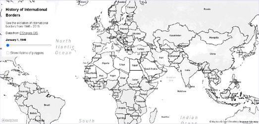
The History of International Borders is a fascinating map showing how country borders around the world have changed since the end of the Second World War. The map allows you to select dates between 1946 and 2016 to view the international borders during that time. Change the date and the map will automatically update to show the country borders as they existed during that period of time.
If you select the 'Show lifetime of polygons' option this will highlight those countries on the map whose borders have changed since World War II. The countries shown in green had stable borders during that period, while the countries colored pink have borders which have changed.
If you are interested in geo-politics then you might want to pay attention to the borders in Eastern Europe after 1990 - during and after the final years of the Union of Soviet Socialist Republics. You might also be interested in the many changing borders in Africa post-1960, as many African countries began to achieve independence from European colonial powers.
One major problem with the map is that the country labels don't change with the changing borders. So for example what is now the Democratic Republic of Congo should be labelled Zaire on the map between 1971 & 1997, and Czechia and Slovakia should more accurately have the one label, Czechoslovakia, before 1993.


Comments