The Luftwaffe Map of Kiev
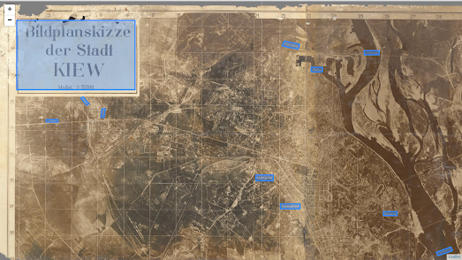
Before the Battle of Kiev (when the Germans captured the city of Kiev in WWII in 1941) the Luftwaffe created a large photographic map of Kiev. To create the map the Luftwaffe made a number of reconnaissance flights to take aerial photographs of the city. These photos were then edited and photographically printed at the local Wehrmacht headquarters, near Kiev, by the German Army ‘Motorized Surveying & Map Detachment’.
The Photographic Map of Kiev also includes a number of placename labels which the Germans added to the map to identify the locations of important infrastructure which were targets for the invading army. These included the harbour, railways stations, bridges and the citadel. Major roads and railway lines were also labeled on the map to indicate the neighboring towns that they led to.
On my Photographic Map of Kiev I have added English translations for the German labels. My map was created using my Leaflet-IIIF-GeoJSON utility tool to add the manifest of the map, to highlight areas on the map and to save the created GeoJSON data. If you are interested in annotating historical vintage maps yourself then you might find these instructions for using Leaflet-IIIF-GeoJSON and Leaflet-IIIF-Annotation helpful.
The Photographic Map of Kiev is owned by the David Rumsey Collection. You can learn more about how the map was made and what it shows on the David Rumsey Map Collection website.


Comments