Google Updates Satellite Imagery of Ukraine
Google Maps has updated some of its satellite imagery of Ukraine, revealing some of the devastating damage caused by the illegal Russian invasion.

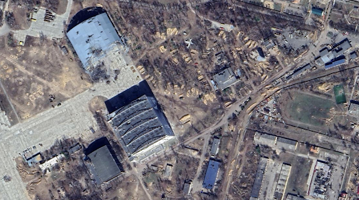
During the siege of Mariupol the theatre was used as an air raid shelter by civilians. On March 16th 2022 Russia bombed the theatre, killing over 600 people. The new Google Maps satellite imagery shows the theatre after the Russian bombing. You can still make out the word 'ДЕТИ' (children) painted on the ground in front of the theatre, which was written in the hope that Russia wouldn't bomb civilians or children.
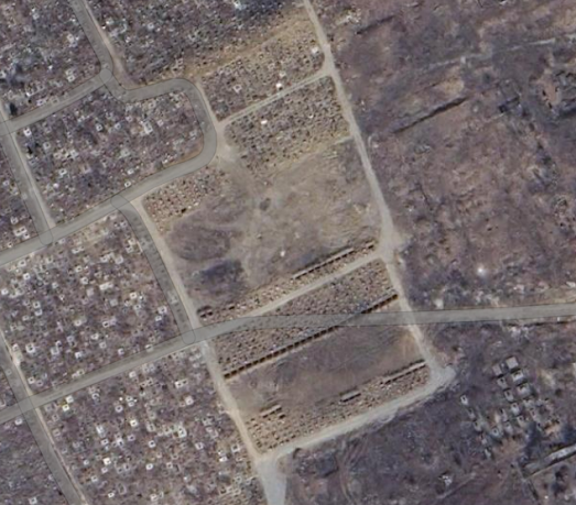
The Mayor of Mariupul, Petr Andryushchenko, claims that the new satellite imagery also reveals new mass graves dug in the Novotroickoe Cemetery in Mariupul.
Undeniable Street View - custom made Street View imagery of just some of the damage that Russia has inflicted on Ukrainian infrastructure.
War Up Close - Street View and 3D imagery of the war in Ukraine
Culture in the Crosshairs - 3D photogrammetry models documenting the destruction of culturally important Ukrainian buildings
360 War - more panoramic 'Street View' imagery from Ukraine
3D Models of Ukraine - Hidenori Watanave's photogrammetry models of destroyed buildings & vehicles
The Virtual Museum of War Memory - custom made Street View panoramas captured at different locations in the Kyiv Oblast.


Comments