Natural Language Mapping
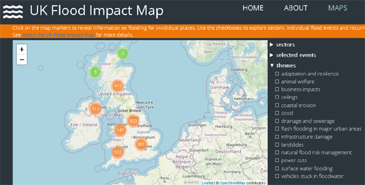
The UK Flood Impact Map is a new interactive map which links locations in the UK which have experienced flooding to newspaper articles which describe the impact of these individual flooding events. Many areas of the UK are particularly susceptible to the increased risk of flooding arising from climate change. It is hoped that the UK Flood Impact Map can help in developing an understanding about how flooding is affecting or could affect key public services and critical infrastructure in the UK.
At the heart of the UK Flood Impact Map is a Natural Language Processing (NLP) technique which uses named entity recognition to identify places and assets in newspaper articles related to flooding. Using NLP over 7,000 local, regional and national newspaper articles were examined to identify news stories about UK flood events. These flood events were then linked to geocoded locations and to specific events, sectors and themes.
The linking of the flood events to locations allows users of the UK Flood Impact Map to search for news articles about flooding events by actual UK locations. The linking of the individual articles to specific events and themes means that users can also search the map by events (e.g. searching for flooding events linked to individual named storms) and by themes (e.g. coastal erosion, flash flooding, drainage).
The UK Flood Impact Map has been released in conjunction with a report published by think tank Bright Blue. In Deep Water? Mapping the Impacts of Flooding in the UK since 2007 (PDF) explores how flooding events (revealed by the NLP of 7,000 news articles) have impacted on key public services, critical infrastructure, and businesses in the UK since 2007.


Comments