Maps of the Week
This month Tommy Caldwell and Kevin Jorgeson became the first climbers to free-climb the 3,000-foot Dawn Wall of El Capitan. The New York Time's The Dawn Wall interactive is an impressive 3d model of their route up the mountain, created by Battista Matasci of the University of Lausanne..
Open The Dawn Wall in a WebGL enabled browser and you can follow Caldwell and Jorgeson's climb on an interactive 3d model of the Dawn Wall. As you scroll down the interactive the model rotates and zooms with impressive speed. Photos and information about the climb can be viewed as you progress along the climbers' route.
Mapbox has released a gorgeous map of all the roads in Japan. OpenStreetMap in Japan only shows Japan's roads and streets and omits all over map features.
The roads on the map are colored by the last date that they were edited on OpenStreetMap. Roads colored blue haven't been edited since 2007. The yellow roads have been edited in the past year. The Mapbox post on the map includes a link to a full-screen map. The map embedded in the post however includes a button to quickly toggle to view close-ups of major cities on the map.
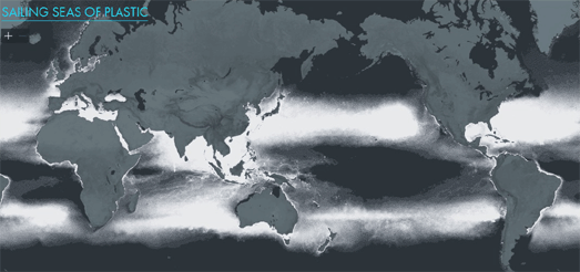
Sailing Seas of Plastic is an interactive mapped visualization of the concentration of plastic in the world's oceans. According to the map there are 5,250 billion pieces of plastic, with a combined weight of 268,940 tonnes, adrift on the seas of the world.
This dot density map shows the estimated concentration of floating plastic in the oceans. Each dot on the map represents 20 kg of floating plastic. The estimations are based on the results of 24 survey expeditions (2007-2013) and on wind and ocean drift models.
You can also overlay the sailing tracks of the 24 survey expeditions on top of the dot map.


Comments