24 Hours of Global Flight Traffic
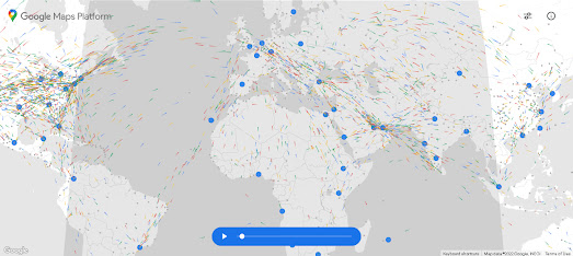
Google has released an animated map visualizing 24 hours of global flight traffic around the world. The WebGL Air Traffic Demo has been released to illustrate what can be achieved using the WebGL features of the Google Maps JavaScript API.
The WebGL overlay view in the Google Maps API allows developers to add and animate 2D and 3D graphics on top of a Google Map. In the WebGL Air Traffic Demo this feature has been used to create a visualization of one day's worth of flights longer than three hours between 645 airports around the world. The map is an impressive demo of the Google Maps API, animating thousands of data points at any one time. The map also includes an animated day/night layer which moves across the map to show the current time of day across the world.

The WebGL Air Traffic Demo was demonstrated yesterday at Google I/O, where Google also gave a sneak peak of a new Immersive View' for Google Maps. Coming later this year for a number of global cities Immersive View combines satellite views, height data and Street View to create what looks like a truly impressive 3D map. The new 'Immersive View' hasn't been launched yet but Google did release a short video demo (shown above).


Comments