A Map of the Drones

Drone Adventures is a non-profit organization designed to promote the potential of drones in conservation, humanitarian work and in search and rescue operations. The organization helps to connect drone operators with people in need of up to the minute aerial imagery.
The Drone Adventures website includes details on projects where aerial imagery captured by drones has been able to help provide up-to-date ground maps. For example, Mapping the Philippines After Typhoon Haiyan, which includes a MapBox map of the captured drone imagery. The imagery and map was then used to carry out damage assessments, identify safe land for relocations and to take stock of recovery efforts.
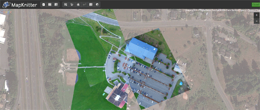
If you ever get around to buying your own drone then you might find MapKnitter useful. MapKnitter is a free and open source tool for aligning and creating maps from overhead images.
The tool allows anyone to take a single aerial image or a series of aerial images and align them, with the help of Google Maps satellite view. Images maps created with MapKnitter can be exported in GeoTiff, TMS/OpenLayers, and JPG formats.
You can explore maps created with the tool by location and the most recent maps are also featured on the home page of MapKnitter.

Dronestagram is an Instagram type application for sharing aerial photos captured by drones. Users can post aerial pictures to Dronestagram and share their photos with the world.
Browsing Dronestagram is a fun way of exploring aerial views of the world. Each photo posted to Dronestagram is accompanied by a Google Map showing where the picture was taken.
If you prefer drone videos to drone photos then TravelByDrone is your best bet. TravelByDrone is a really interesting Google Map of video footage taken by drones around the world. The map includes some fascinating aerial video footage captured by people using drones equipped with video cameras.
Many of the videos featured on the map are of a very high quality and provide a unique aerial view of locations around the world. TravelByDrone already features a lot of drone captured videos. It also includes an option to submit a drone video to the map so TravelByDrone should become a great central repository of aerial videos shot by unmanned drones.


Comments