The Kremer Collection on Google Maps
Yesterday I was at the London Google Developers Day at Wembley, so I'm very grateful for the huge effort put in by Renaud Euvrard on his 20 Best French Google Maps Mash-ups post.
During the presentations yesterday I saw some great examples of Google Maps mash-ups but by far my favourite was from the Kremer Collection.
The Kremer Collection
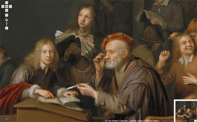
The Foundation Aetas Aurea's collection of 17th century Dutch and Flemish Old Masters is now viewable via the Google Maps interface. Twenty five paintings from the collection have been made into custom tiles and are used instead of the map tiles in 25 separate Google Maps mash-ups.
This means that the viewer can examine any one of the 25 paintings in close detail by panning and zooming in on any section using the Google Maps navigation tools. To create the custom map tiles The Kremer Collection has used CASA's image cutter. Using this tool, large images can easily be turned into custom tiles for Google Maps. You just need to spend a few minutes viewing The Kremer Collection in Google Maps to realise the advantages of presenting paintings on the web via the Google Maps interface.

__________
During the presentations yesterday I saw some great examples of Google Maps mash-ups but by far my favourite was from the Kremer Collection.
The Kremer Collection
The Foundation Aetas Aurea's collection of 17th century Dutch and Flemish Old Masters is now viewable via the Google Maps interface. Twenty five paintings from the collection have been made into custom tiles and are used instead of the map tiles in 25 separate Google Maps mash-ups.
This means that the viewer can examine any one of the 25 paintings in close detail by panning and zooming in on any section using the Google Maps navigation tools. To create the custom map tiles The Kremer Collection has used CASA's image cutter. Using this tool, large images can easily be turned into custom tiles for Google Maps. You just need to spend a few minutes viewing The Kremer Collection in Google Maps to realise the advantages of presenting paintings on the web via the Google Maps interface.
__________


Comments
a hint/tips make sure that your HTML file is saved as UTF-8 format other wise if you in the copyright field using text/signs outside english language it would looks strange. ex. danish æ,ø and å
a danish example created with Image Cutter "HTML saved as utf-8" with a painting can be viewed here