The Funniest Maps of the Year (2014)

Springfield is a gloriously detailed map of the most famous of town in America. From the world's first ever Kwik-E-Mart to Springfield Elementary School, this Spingfield map has it all. You can even use the map to look up the address of individual families, for example the Simpsons family at 742 Evergreen Terrace.
Even though this is undoubtedly the best Simpsons map ever - I still want more. Where is the Springfield Street View (I bet even Shelbyville has Street View by now)? I also want driving directions. I need to know the quickest way to the Kwik-E-Mart and to the Springfield Nuclear Power Plant (preferably with real-time traffic conditions).
Another thing missing from the map is transit directions. It would be handy to know which bus I need to catch to get to Moe's Tavern. However, nit-picking aside, this is still the best Springfield map I've ever seen. It's quite possibly the best map ever.

Alternate history novels have been very popular over the last few years. So surely there must be a market for alternate history maps. Newcastle Brown Ale obviously think so.
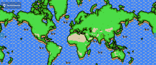
Last year, for Independence Day, the brewer released an alternate history map of the United States. If We Won is a brilliant map of the USA showing how the country might have looked if the American War of Independence had been won by Great Britain.
Enter any town or city into the map and you can discover what the location would be named if the Americans hadn't been so unhappy about paying their taxes. For example El Paso becomes Ye Olde Paso, Charlotte becomes North Charlottesvilleford and San Francisco becomes Wolverhampton.

One of the earliest popular uses of the Google Maps API was Gawker Stalker. The now defunct Gawker Stalker allowed you to track the movements of your favorite celebrities thanks to the detailed stalking carried out by Gawker and their readers.
If there is one thing more popular than celebrities on the internet then that must be pictures of cats. It is therefore surprising that we have had to wait seven years for someone to finally get around to releasing I Know Where Your Cat Lives.
I Know Where Your Cat Lives displays pictures of cats on a Google Map. The pictures of the cats come from popular photo sharing websites and the locations are based on the data hidden in cat photo metadata. I'm guessing that the map is partly intended as a warning about sharing your personal information online (or maybe its just a warning about sharing your cat's personal data online).

MTA.me Conductor has turned Massimo Vignelli's 1972 New York subway map into a real-time string instrument. The map visualizes in real-time trains moving on the MTA subway network and plays a note every time a subway train crosses the track of another train.
Every minute the application checks for new trains launched from their end stations. The trains are then animated along the subway line with their speed set by the MTA schedule. When one train crosses the track of another train a single note is played.
Fire-up the map and you can just sit back and listen to a New York subway symphony being composed and played in real-time. You can even join in the composition by plucking the strings of the trains of the New York subway.
If you've ever wondered how Mario and Luigi manage to navigate so effortlessly around the Mushroom Kingdom and Dinosaur Land then you need to check out this Super Mario map from Duncan Graham. This interactive map reimagines the world as an 8-bit map in the style of Nintendo's classic game, complete with golden coins and mushrooms.
Accompanying the map is a great 'how-to' guide on how the map was created with Mapbox Studio. It's worth reading the article if you want to learn about importing land or water source files into Mapbox Studio, how to add custom elements to your map and how to order layers.

Apparently people defecating on the streets is a thing in San Francisco. At least it is a big enough problem for Jennifer Wong to think it warrants its own interactive map. Obviously this seems to be a serious issue for San Francisco but there is an element of humor in the presentation of this map.
Jennifer has used San Francisco Department of Public Works data of sidewalk cleanings for 'human waste or urine' to create the (Human) Wasteland map. The map makes use of the Google Maps Styled Maps feature to provide a context-appropriate colored base map. The same 'appropriate' colors are used in the heat map layer. If you want you can filter the crap on the map by month and search the map by address.

I really do have the mental age of a five year old. There is no other excuse for the enjoyment I got from creating this Talking Rude Map.
The map animates through some of the more NSFW place-names around the world and reads the names out loud. I don't think that this map will work with any other browser but Chrome. If you don't use Chrome don't blame me if you don't get past the F#cking first page.

It only takes one letter to go viral. Google Naps became a very popular map for a brief period in 2014. A map of good places to take forty winks could on it own prove relatively popular but my guess is that its brief viral status sprang from its punning name.
I suspect that right now map developers around the world are working on other puns on the words 'Google Maps'. This year I expect to be reviewing a map of rugs around the world (Google Mats), a map of drinking fountains (Google Taps) and a map of public rest-rooms (I leave that one to your imagination).


Comments