Marine Maps
In anticipation of today's release of Google Ocean (Google Earth) it seems appropriate to post a round up of some of the better marine maps featured on Google Maps Mania over the years. Of course all of these maps are concerned with what floats on top of the world's oceans and not on what lies beneath.
MarineTraffic.com
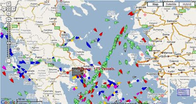
MarineTraffic.com have produced a Google Map showing real-time information about ship movements throughout the world.
The system is based on AIS (Automatic Identification System). The International Maritime Organization (IMO) requires all vessels over 299GT to carry an AIS transponder on board, which transmits data on position, speed and course, among some other static information, such as the vessel’s name, dimensions and voyage details.
Live Piracy Map 2008
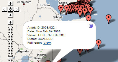
This Live Piracy Map 2008 by the International Chamber of Commerce purports to show all the piracy and armed robbery incidents reported to the IMB Piracy Reporting Centre during 2008.
Bluemapia
Bluemapia is a boating social network built around Google Maps.
Users can create placemarks, points of interest and plot their boat trips on a Google Map. They can also geotag photographs and videos of their voyages directly onto the map and use the map to view points of interest added by others.
Hi-Def San Francisco

Hi-Def San Francisco tracks in real time all the ships in San Francisco Bay. Every commercial vessel, and some large pleasure craft, in the bay transmit their position using AIS, which allows Hi-Def to up-date the position of ships on the map every 15 seconds.
Hi-Def also takes a photograph of every vessel as it crosses an imaginary line between the camera and the Trans America building. This means that when you click on a tagged ship on the map you can actually see a recent photograph of that very ship.
Marine Map

MarineMap is a hugely impressive Google Map mashup of the California coastline and marine protected areas (MPAs). The map has a large number of features and manages to include a massive amount of data.
The stated aim of MarineMap is to assist organizations involved in mapping of the oceanographic, biological, geological, chemical, and human dimensions of the ocean and coastal areas. They provide organizations with customized solutions for data storage, data sharing, and web-based mapping.
________________
MarineTraffic.com
MarineTraffic.com have produced a Google Map showing real-time information about ship movements throughout the world.
The system is based on AIS (Automatic Identification System). The International Maritime Organization (IMO) requires all vessels over 299GT to carry an AIS transponder on board, which transmits data on position, speed and course, among some other static information, such as the vessel’s name, dimensions and voyage details.
Live Piracy Map 2008
This Live Piracy Map 2008 by the International Chamber of Commerce purports to show all the piracy and armed robbery incidents reported to the IMB Piracy Reporting Centre during 2008.
Bluemapia
Bluemapia is a boating social network built around Google Maps.
Users can create placemarks, points of interest and plot their boat trips on a Google Map. They can also geotag photographs and videos of their voyages directly onto the map and use the map to view points of interest added by others.
Hi-Def San Francisco
Hi-Def San Francisco tracks in real time all the ships in San Francisco Bay. Every commercial vessel, and some large pleasure craft, in the bay transmit their position using AIS, which allows Hi-Def to up-date the position of ships on the map every 15 seconds.
Hi-Def also takes a photograph of every vessel as it crosses an imaginary line between the camera and the Trans America building. This means that when you click on a tagged ship on the map you can actually see a recent photograph of that very ship.
Marine Map
MarineMap is a hugely impressive Google Map mashup of the California coastline and marine protected areas (MPAs). The map has a large number of features and manages to include a massive amount of data.
The stated aim of MarineMap is to assist organizations involved in mapping of the oceanographic, biological, geological, chemical, and human dimensions of the ocean and coastal areas. They provide organizations with customized solutions for data storage, data sharing, and web-based mapping.
________________


Comments