Freestyle Downhill Water Mapping
Andy Woodruff has invented a kind of hydrodynamics physics engine for interactive maps. It allows him to create an animated map which visualizes water drainage flow for any location on Earth.
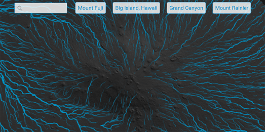
In the Rain on the Terrain Andy tries to answer the question of where water would flow if you poured it over the terrain at any location on the planet. His solution is essentially to use elevation data to find the lowest adjacent location for any given location. Drop some water at this location and it will find the path of least resistance and move to the adjacent location with this lowest elevation.
Repeat this process and you can plot a long path of the least resistance, moving downhill. If you then animate a polyline along this path you can create a map of flowing rivers. Andy's map allows you to visualize the animated flow map of drainage for any location on Earth (based on his simple algorithm). The map also includes some quick links to zoom the map to a number of locations with interesting terrain.


Comments