Checking Water Quality with Google Maps
Water Atlas
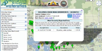
This Water Atlas Google Map from the Hillsborough County and City of Tampa allows citizens to check water quality, hydrology, rainfall and weather data from the county's water stations.
The green map markers indicate stations with current data (anywhere from the last 60 seconds to the last 24 hours). The yellow markers show inactive stations (maybe because of maintenance or technical problems).
Depending on the type of water station selected you can view, daily rainfall, precipitation, water flow, elevation, temperature, velocity and conductance. Each information window also includes a link to view graphs of the stations recorded data for the last 24 hours, week and month.
________________


Comments