Mapping Fraccidents

Earth Justice has released a map showing the location of accidents related to the rise of fracking in the USA. Fracking Accidents Across the United States uses the Google Maps API to plot accidents such as poisoned drinking water, polluted air, mysterious animal deaths, industrial disasters and explosions, which have been connected to oil and gas drilling.
The map includes two overlays which show areas where fracking is active and areas of potential fracking. The accidents themselves are shown on the map by skull and crossbones map markers. The data source for each incident is included in the detailed report of each fracking accident.

StateImpact Pennsylvania has released a series of mapped visualizations of Natural Gas Drilling in Pennsylvania.
The maps show which operators are drilling in Pennsylvania and where. They also show which wells have been cited for violating state environmental regulations. So far there have been over 3,800 violations resulting in fines of $5.9 million. The drills are displayed on the map with color-coded markers to show the wells with no violations and those with one or more violations.
You can select individual wells on the map to view details about the operator and any violations.

Faces of Fracking is an investigation into how the impacts of fracking are being felt in California.
This story map visualization, built using d3.js, plots the locations of the 532 oil & gas wells in the LA Basin. As you scroll through the investigation the map also plots the number of pounds of toxic chemicals released at each fracking site.
Continue scrolling and the map zooms out to show the 3,014 wells across California, where high–intensity production is either planned or already taking place, and the 1,105 wells where waste is being injected into the ground. You can also view the proximity of each of these wells to California's groundwater aquifers.
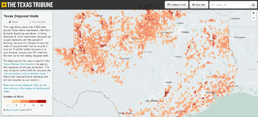
The Texas Tribune has published a map showing the location of disposal wells where waste-water, often from hydraulic fracturing sites, is being disposed of in the state. Texas Disposal Wells visualizes the location of 7,000 disposal wells in Texas.
The map uses hexagonal binning to highlight the number of wells within an area. You can zoom in on the map to view the location of the individual wells.
The Texas Tribune uses the Mapbox platform. Mapbox has written a nice tutorial on how to use hexagonal binning with Mapbox created maps. Binning: an Alternative to Pointmaps explains how the free and open source QuantumGIS tool can be used to create a hexagon density layer, which you can then overlay on top of a Mapbox map.

Colorado experiences, on average, one oil spill a day. In total that is 4,900 spills in the last thirteen years. The result of all those oil spills was the release of nearly 102 million gallons of oil, drilling fluids and other toxic materials into the environment.
The Western Toxic Release Map shows the location of 13,600 spills in Colorado and New Mexico between 2000 and 2013. You can click on any of the spills displayed on the map to view the date of the spill and the number of gallons spilled. You can also click-through to view the full Oil Conservation Division report on the spill.
You can filter the results shown on the map by year or view the total 14 years of oil spills in one go.


Comments