The New Berlin Wall

The Nokia HERE blog has been looking at historical maps of Berlin to see how map makers in pre-unification Germany represented the presence of the Berlin Wall and East and West Berlin in maps. In History of the Berlin Wall Through Maps CJ Schuler examines how cartographers in East and West Germany responded to the partition of the city.
The post looks at a series of maps, including this 1988 map (screenshot above) from East Germany, which shows West Berlin simply as a huge hole in the map.

Twenty-five years ago this November the Berlin Wall was torn down. Since then Berlin has been transformed. The Berliner Morgenpost has published a great aerial view map of Berlin which allows you to compare the modern day Berlin with the Berlin of 1989.
Using the Berliner Morgenpost's interactive map Die Narbe der Stadt you can switch between aerial views of Berlin from 1989 and aerial views of Berlin today. A menu in the top-left corner of the map provides quick links to some important locations in the city which have been transformed in the twenty-five years since the wall was torn down.
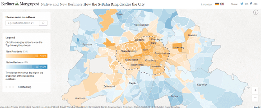
The Berliner Morgenpost has also created a new map of Berlin which reveals a new dividing line in the city. How the S-Bahn Ring Divides the City is a map of the German capital in which the neighborhoods have been colored to show whether most of the inhabitants were born in or outside Berlin.
The map reveals that within the S-Bahn ring in every neighborhood, except Neu-Templhof, the majority of the residents were born outside Berlin. Outside the S-Bahn ring many of the neighborhoods are dominated by native Berliners.


Comments